|
drawmap
The U.S. Geological Survey (USGS) supports sites on the Internet with
many gigabytes of raw geographic data, mostly for the USA.
(Some locations for these sites are given in the drawmap manual page.)
Drawmap draws maps, using a subset of the available USGS data for the USA.
The relevant subset includes:
- 250K Digital Elevation Model (DEM) files --
Each file covers a block, one-degree square, with a 1201 by 1201 grid of elevations (in meters).
The extra sample in each direction is due to overlap of the DEM files at their edges.
(Files for Alaska use smaller grids, with only 401 or 601 samples in the east-west direction.)
For Hawaii and the "lower 48," the one-degree square is covered by elevation samples
spaced 3 seconds apart.
In terms of distance along the ground, the sample spacing varies with latitude.
It is generally less than 100 meters.
- 100K Digital Line Graph (DLG) files (in the 'optional' format) --
These files come in collections, each of which covers a quarter of the one-degree
square covered by a DEM file. The files contain information that allows segmented
linear and polygonal features to be drawn on maps, including boundary lines,
hydrographic features (streams, lakes, and so on),
transportation features (roads, rail lines, pipelines, and so on),
public land survey data, and hypsographic lines (the familiar contour lines of a topographic map).
The different general classes of data come in separate files.
- Geographic Names Information System (GNIS) files --
These files contain lists of place names, complete with their latitude/longitude and other information.
Using the data in these files, drawmap
can produce various kinds of customized maps, including shaded relief maps (with or without roads, streams,
place names, and so on) and topographic maps (again, with or without additional features).
You can look at some examples by clicking for screen shots below.
Drawmap is not a window based application. It runs from a command-line prompt and produces an
image file in SUN Rasterfile format. The image file can then be viewed with your favorite
image viewer, or converted to other image formats as desired.
|
|
Current Version: 1.7
License Type: GPL
|
|
Home Site:
http://metalab.unc.edu/pub/Linux/science/cartography/ (drawmap.*)
Source Code Availability: Yes
Available Binary Packages: None, at present. Should readily compile on most UNIX systems.
- Debian Package: No
- RedHat RPM Package: No
- Other Packages: None
Targeted Platforms:
Linux/X86, and other UNIX systems
Software/Hardware Requirements:
While working, drawmap stores the entire map in memory. Large maps require large memory.
|
|
Other Links:
None
Mailing Lists/USENET News Groups:
None
User Comments:
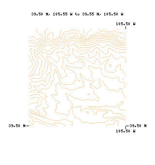
See Some Screen Shots?
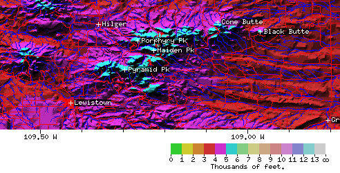
- Relief, with roads and streams, near Lewistown, MT.
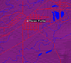
- Expanded detail of streets and roads around Three Forks, MT.
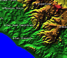
- Relief, with place names, near San Clemente, CA.
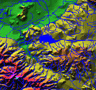
- Relief, with hydrographic features, in Southern California.
- Contour map, with no added features, for a region west of Denver, CO.
|


 SAL Home
|
SAL Home
|  Computer Graphics, Images & Signals
|
Computer Graphics, Images & Signals
|  Geographic Information Systems